cales st sauveur cci

cps46
User
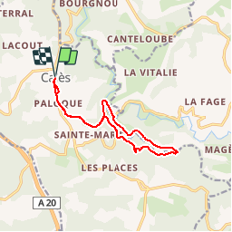

Length
12.7 km

Max alt
275 m

Uphill gradient
315 m
Km-Effort
16.9 km

Min alt
107 m

Downhill gradient
315 m
Boucle
Yes
Creation date :
2016-09-10 00:00:00.0
Updated on :
2016-09-10 00:00:00.0
1h46
Difficulty : Unknown

FREE GPS app for hiking
 SityTrail
IGN / Geographical institutes
SityTrail Plus
The world is yours!
About
Trail Walking of 12.7 km to be discovered at Occitania, Lot, Calès. This trail is proposed by cps46.


Positioning
Country:
France
Region :
Occitania
Department/Province :
Lot
Municipality :
Calès
Location:
Unknown
Start:(Dec)
Start:(UTM)
384427 ; 4962948 (31T) N.
Comments