


AREMIG 2016-Vandoeuvre

nicolas54230
User
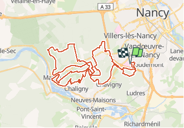

Length
52 km

Max alt
418 m

Uphill gradient
904 m
Km-Effort
64 km

Min alt
237 m

Downhill gradient
901 m
Boucle
Yes
Creation date :
2016-09-11 00:00:00.0
Updated on :
2016-09-11 00:00:00.0
4h06
Difficulty : Medium

FREE GPS app for hiking
 SityTrail
IGN / Geographical institutes
SityTrail Plus
The world is yours!
About
Trail Mountain bike of 52 km to be discovered at Grand Est, Meurthe-et-Moselle, Vandœuvre-lès-Nancy. This trail is proposed by nicolas54230.
Description
AREMIG 2016-Vandoeuvre
Positioning
Country:
France
Region :
Grand Est
Department/Province :
Meurthe-et-Moselle
Municipality :
Vandœuvre-lès-Nancy
Location:
Unknown
Start:(Dec)
Start:(UTM)
290357 ; 5392256 (32U) N.
Comments