


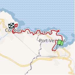
Port Vendre - Collioure

Gegetop
User

Length
7.7 km

Max alt
48 m

Uphill gradient
128 m
Km-Effort
9.4 km

Min alt
-2 m

Downhill gradient
119 m
Boucle
No
Creation date :
2016-09-12 00:00:00.0
Updated on :
2018-08-20 07:29:07.825
2h38
Difficulty : Easy

FREE GPS app for hiking
 SityTrail
IGN / Geographical institutes
SityTrail Plus
The world is yours!
About
Trail Walking of 7.7 km to be discovered at Occitania, Pyrénées-Orientales, Port-Vendres. This trail is proposed by Gegetop.
Positioning
Country:
France
Region :
Occitania
Department/Province :
Pyrénées-Orientales
Municipality :
Port-Vendres
Location:
Unknown
Start:(Dec)
Start:(UTM)
508863 ; 4707146 (31T) N.
Comments