


SG - Navacelles - Les Natges

nolsim
User
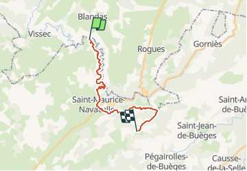

Length
21 km

Max alt
626 m

Uphill gradient
659 m
Km-Effort
29 km

Min alt
262 m

Downhill gradient
520 m
Boucle
No
Creation date :
2018-08-18 14:07:48.942
Updated on :
2018-08-18 14:07:48.942
6h31
Difficulty : Difficult

FREE GPS app for hiking
 SityTrail
IGN / Geographical institutes
SityTrail Plus
The world is yours!
About
Trail Walking of 21 km to be discovered at Occitania, Hérault, Saint-Maurice-Navacelles. This trail is proposed by nolsim.
Photos


Positioning
Country:
France
Region :
Occitania
Department/Province :
Hérault
Municipality :
Saint-Maurice-Navacelles
Location:
Unknown
Start:(Dec)
Start:(UTM)
540993 ; 4860313 (31T) N.
Comments