


PREPA Ardèche J4 - VallonPontDarc-GrChauvet

randodan
User
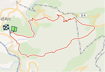

Length
12 km

Max alt
427 m

Uphill gradient
421 m
Km-Effort
17.6 km

Min alt
86 m

Downhill gradient
412 m
Boucle
Yes
Creation date :
2016-09-13 00:00:00.0
Updated on :
2016-09-13 00:00:00.0
10m
Difficulty : Unknown

FREE GPS app for hiking
 SityTrail
IGN / Geographical institutes
SityTrail Plus
The world is yours!
About
Trail Other activity of 12 km to be discovered at Auvergne-Rhône-Alpes, Ardèche, Vallon-Pont-d'Arc. This trail is proposed by randodan.
Positioning
Country:
France
Region :
Auvergne-Rhône-Alpes
Department/Province :
Ardèche
Municipality :
Vallon-Pont-d'Arc
Location:
Unknown
Start:(Dec)
Start:(UTM)
611709 ; 4917002 (31T) N.
Comments