


le thillot

jeanluc59
User
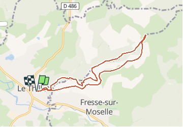

Length
7.8 km

Max alt
838 m

Uphill gradient
368 m
Km-Effort
12.7 km

Min alt
511 m

Downhill gradient
369 m
Boucle
Yes
Creation date :
2016-09-21 00:00:00.0
Updated on :
2016-09-21 00:00:00.0
2h45
Difficulty : Easy

FREE GPS app for hiking
 SityTrail
IGN / Geographical institutes
SityTrail Plus
The world is yours!
About
Trail Walking of 7.8 km to be discovered at Grand Est, Vosges, Le Thillot. This trail is proposed by jeanluc59.
Description
la chapelle des ves
Positioning
Country:
France
Region :
Grand Est
Department/Province :
Vosges
Municipality :
Le Thillot
Location:
Unknown
Start:(Dec)
Start:(UTM)
333057 ; 5305403 (32T) N.
Comments