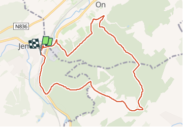
Jemelle ADEPS 09-2016

Wernerch
User

Length
9.8 km

Max alt
364 m

Uphill gradient
367 m
Km-Effort
14.7 km

Min alt
193 m

Downhill gradient
367 m
Boucle
Yes
Creation date :
2016-09-20 00:00:00.0
Updated on :
2023-08-12 17:55:18.708
1h49
Difficulty : Difficult

FREE GPS app for hiking
 SityTrail
IGN / Geographical institutes
SityTrail Plus
The world is yours!
About
Trail Walking of 9.8 km to be discovered at Wallonia, Namur, Rochefort. This trail is proposed by Wernerch.
Description
gare de Jemelle -route de Forrieres quelques centaines de mètres de tarmac avant un parcours boisé avec un dénivelé important.
Difficulté :de moyen vers difficile !!!
Positioning
Country:
Belgium
Region :
Wallonia
Department/Province :
Namur
Municipality :
Rochefort
Location:
Jemelle
Start:(Dec)
Start:(UTM)
661823 ; 5558986 (31U) N.
Comments