Trail Walking Genainville - Genainville - Bois de Morlû - Photo

Genainville - Bois de Morlû

 marcel.F
marcel.F

User

© OpenStreetMap contributors
Length
Length
12.2 km
Max alt
Max alt
141 m
Uphill gradient
Uphill gradient
203 m
Km-Effort
Km-Effort  
14.9 km
Min alt
Min alt
77 m
Downhill gradient
Downhill gradient
203 m
Boucle
Boucle
Yes
Creation date :
2019-04-01 20:23:20.963
Updated on :
2019-04-01 20:23:21.014

(0 Reviews)

Walking
Walking
3h13
Difficulty : Easy

Scan this QR Code to open this trail in the SityTrail application

FREE GPS app for hiking

Logo SityTrail SityTrail

IGN / Geographical institutes

Download SityTrail from the App Store Download SityTrail from Google Play

Logo SityTrail SityTrail World

The world is yours!

Download SityTrail from the App Store Download SityTrail from Google Play Download SityTrail on Huawei AppGallery

About

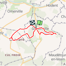
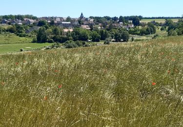
Trail Walking of 12.2 km to be discovered at Ile-de-France, Val-d'Oise, Genainville. This trail is proposed by marcel.F.

Description

Boucle au départ du parking de la salle des loisirs de Genainville

Elevation profile

Positioning

Country:
France
Region :
Ile-de-France
Department/Province :
Val-d'Oise
Municipality :
Genainville
Location:
Unknown
Start:(UTM)
408557 ; 5442128 (31U) N.

Trails nearby

Trail Walking Arthies - Petite Randonnée des Cinq châteaux - Arthies - Photo
Walking
tracegps

Walking

Medium
(2)
Arthies, Ile-de-France, Val-d'Oise, France
14 km | 17.3 km-effort
3h 0min
Yes
Trail Walking Chaussy - Chaussy - Villarceaux vers Chaussy - Photo
Walking
marcel.F

Walking

Easy
(1)
Chaussy, Ile-de-France, Val-d'Oise, France
10.4 km | 12.9 km-effort
2h 48min
Yes
Trail Walking Chaussy - Chaussy - Villarceaux - Genainville - Photo
Walking
marcel.F

Walking

Easy
(1)
Chaussy, Ile-de-France, Val-d'Oise, France
11.3 km | 13.7 km-effort
2h 57min
Yes
Trail Equestrian Magny-en-Vexin - Magny - Le Bouleaume - Chars  - Photo
Equestrian
garou95

Equestrian

Medium
(1)
Magny-en-Vexin, Ile-de-France, Val-d'Oise, France
28 km | 32 km-effort
3h 38min
No
Trail Walking Omerville - omerville et alentours - Photo
Walking
pactometo

Walking

Easy
(3)
Omerville, Ile-de-France, Val-d'Oise, France
12.7 km | 16 km-effort
3h 17min
Yes
Trail On foot Magny-en-Vexin - De Magny-en-Vexin à Mantes-la-Jolie - Photo
On foot
PRO

On foot

Difficult
Magny-en-Vexin, Ile-de-France, Val-d'Oise, France
30 km | 37 km-effort
8h 20min
No
Trail Walking Magny-en-Vexin - Magny en vexin - Photo
Walking
avdem

Walking

Very easy
Magny-en-Vexin, Ile-de-France, Val-d'Oise, France
12.1 km | 13.8 km-effort
2h 49min
Yes
Trail Walking Omerville - 180503 - Omerville - Photo
Walking
domelisa78

Walking

Easy
(1)
Omerville, Ile-de-France, Val-d'Oise, France
13.3 km | 17.4 km-effort
3h 21min
Yes
Trail Walking Omerville - Omerville - Photo
Walking
Fky78

Walking

Difficult
Omerville, Ile-de-France, Val-d'Oise, France
12.6 km | 16.5 km-effort
3h 44min
Yes


Close
My subscriptions