


Fursac

csy95
User

Length
10.9 km

Max alt
440 m

Uphill gradient
204 m
Km-Effort
13.6 km

Min alt
319 m

Downhill gradient
204 m
Boucle
Yes
Creation date :
2018-08-26 10:57:50.577
Updated on :
2018-08-26 10:57:50.62
2h33
Difficulty : Medium

FREE GPS app for hiking
 SityTrail
IGN / Geographical institutes
SityTrail Plus
The world is yours!
About
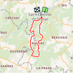
Trail Walking of 10.9 km to be discovered at New Aquitaine, Creuse, Fursac. This trail is proposed by csy95.
Positioning
Country:
France
Region :
New Aquitaine
Department/Province :
Creuse
Municipality :
Fursac
Location:
Saint-Étienne-de-Fursac
Start:(Dec)
Start:(UTM)
385147 ; 5111318 (31T) N.
Comments