


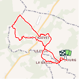
La vallée de l'or et du Frény

alainjoseph6
User

Length
10.7 km

Max alt
191 m

Uphill gradient
165 m
Km-Effort
12.9 km

Min alt
143 m

Downhill gradient
161 m
Boucle
Yes
Creation date :
2016-09-29 00:00:00.0
Updated on :
2016-09-29 00:00:00.0
2h31
Difficulty : Easy

FREE GPS app for hiking
 SityTrail
IGN / Geographical institutes
SityTrail Plus
The world is yours!
About
Trail Walking of 10.7 km to be discovered at New Aquitaine, Charente, Saint-Coutant. This trail is proposed by alainjoseph6.
Description
Très agréable et ombragée
Photos


Positioning
Country:
France
Region :
New Aquitaine
Department/Province :
Charente
Municipality :
Saint-Coutant
Location:
Unknown
Start:(Dec)
Start:(UTM)
302356 ; 5097622 (31T) N.
Comments