


Chalet de Charvant

whisper73
User
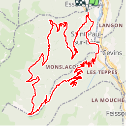

Length
37 km

Max alt
1637 m

Uphill gradient
1563 m
Km-Effort
58 km

Min alt
382 m

Downhill gradient
1564 m
Boucle
Yes
Creation date :
2016-10-02 00:00:00.0
Updated on :
2016-10-02 00:00:00.0
3h41
Difficulty : Medium

FREE GPS app for hiking
 SityTrail
IGN / Geographical institutes
SityTrail Plus
The world is yours!
About
Trail Mountain bike of 37 km to be discovered at Auvergne-Rhône-Alpes, Savoy, Saint-Paul-sur-Isère. This trail is proposed by whisper73.
Positioning
Country:
France
Region :
Auvergne-Rhône-Alpes
Department/Province :
Savoy
Municipality :
Saint-Paul-sur-Isère
Location:
Unknown
Start:(Dec)
Start:(UTM)
300260 ; 5053940 (32T) N.
Comments