


TOUR 2

UDGI54
User

Length
11.9 km

Max alt
1527 m

Uphill gradient
265 m
Km-Effort
18.5 km

Min alt
616 m

Downhill gradient
1160 m
Boucle
No
Creation date :
2016-10-02 00:00:00.0
Updated on :
2016-10-02 00:00:00.0
--
Difficulty : Unknown

FREE GPS app for hiking
 SityTrail
IGN / Geographical institutes
SityTrail Plus
The world is yours!
About
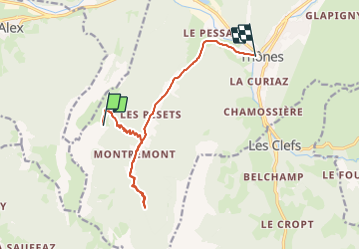
Trail Walking of 11.9 km to be discovered at Auvergne-Rhône-Alpes, Upper Savoy, Thônes. This trail is proposed by UDGI54.
Positioning
Country:
France
Region :
Auvergne-Rhône-Alpes
Department/Province :
Upper Savoy
Municipality :
Thônes
Location:
Unknown
Start:(Dec)
Start:(UTM)
288062 ; 5082697 (32T) N.
Comments