


rando 4

cedric.fargues
User
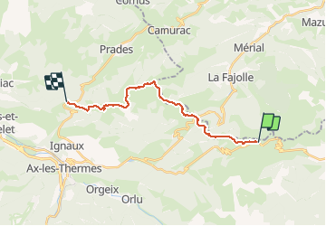

Length
17.9 km

Max alt
1964 m

Uphill gradient
406 m
Km-Effort
25 km

Min alt
1453 m

Downhill gradient
878 m
Boucle
No
Creation date :
2016-10-06 00:00:00.0
Updated on :
2016-10-06 00:00:00.0
5h46
Difficulty : Unknown

FREE GPS app for hiking
 SityTrail
IGN / Geographical institutes
SityTrail Plus
The world is yours!
About
Trail Other activity of 17.9 km to be discovered at Occitania, Ariège, Ascou. This trail is proposed by cedric.fargues.
Positioning
Country:
France
Region :
Occitania
Department/Province :
Ariège
Municipality :
Ascou
Location:
Unknown
Start:(Dec)
Start:(UTM)
416933 ; 4731787 (31T) N.
Comments