


Anvers Valmondoit

avdem
User
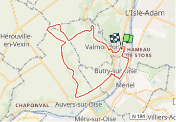

Length
18.1 km

Max alt
109 m

Uphill gradient
199 m
Km-Effort
21 km

Min alt
21 m

Downhill gradient
197 m
Boucle
Yes
Creation date :
2016-10-06 00:00:00.0
Updated on :
2016-10-06 00:00:00.0
3h19
Difficulty : Unknown

FREE GPS app for hiking
 SityTrail
IGN / Geographical institutes
SityTrail Plus
The world is yours!
About
Trail Other activity of 18.1 km to be discovered at Ile-de-France, Val-d'Oise, Parmain. This trail is proposed by avdem.
Positioning
Country:
France
Region :
Ile-de-France
Department/Province :
Val-d'Oise
Municipality :
Parmain
Location:
Unknown
Start:(Dec)
Start:(UTM)
441755 ; 5438367 (31U) N.
Comments