Anthee

Wernerch
User
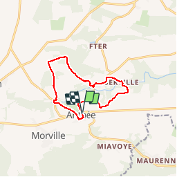

Length
10.1 km

Max alt
294 m

Uphill gradient
214 m
Km-Effort
12.9 km

Min alt
204 m

Downhill gradient
217 m
Boucle
Yes
Creation date :
2016-10-09 00:00:00.0
Updated on :
2019-08-30 16:30:28.056
1h39
Difficulty : Easy

FREE GPS app for hiking
 SityTrail
IGN / Geographical institutes
SityTrail Plus
The world is yours!
About
Trail Walking of 10.1 km to be discovered at Wallonia, Namur, Onhaye. This trail is proposed by Wernerch.
Description
De jolies découvertes les villages de Serville et de Ostemerée.
Une belle région à revisiter hors période de chasses.
Positioning
Country:
Belgium
Region :
Wallonia
Department/Province :
Namur
Municipality :
Onhaye
Location:
Anthée
Start:(Dec)
Start:(UTM)
625573 ; 5566829 (31U) N.
Comments