


SOISSONS ET ALENTOURS

NUITEVEN
User
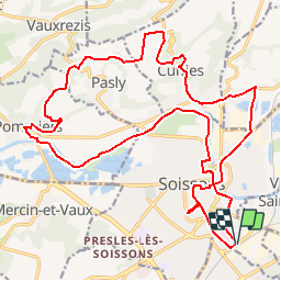

Length
24 km

Max alt
147 m

Uphill gradient
241 m
Km-Effort
28 km

Min alt
34 m

Downhill gradient
241 m
Boucle
Yes
Creation date :
2017-04-15 00:00:00.0
Updated on :
2017-04-15 00:00:00.0
6h02
Difficulty : Easy

FREE GPS app for hiking
 SityTrail
IGN / Geographical institutes
SityTrail Plus
The world is yours!
About
Trail Walking of 24 km to be discovered at Hauts-de-France, Aisne, Soissons. This trail is proposed by NUITEVEN.
Positioning
Country:
France
Region :
Hauts-de-France
Department/Province :
Aisne
Municipality :
Soissons
Location:
Unknown
Start:(Dec)
Start:(UTM)
524542 ; 5468585 (31U) N.
Comments