


Coupvray

GOELERANDO2
User

Length
22 km

Max alt
129 m

Uphill gradient
249 m
Km-Effort
25 km

Min alt
37 m

Downhill gradient
249 m
Boucle
Yes
Creation date :
2016-10-18 00:00:00.0
Updated on :
2016-10-18 00:00:00.0
5h22
Difficulty : Difficult

FREE GPS app for hiking
 SityTrail
IGN / Geographical institutes
SityTrail Plus
The world is yours!
About
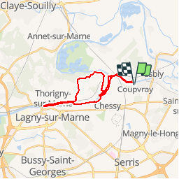
Trail Walking of 22 km to be discovered at Ile-de-France, Seine-et-Marne, Coupvray. This trail is proposed by GOELERANDO2.
Description
Parking rue de Lesches vers le musée Braille de Coupvray.
Départ au pied du pont sur le canal de Meaux.
Carte IGN 2414 ET
Long. 2°47.53,E
Lat. 48°53.73, N
A/R 54 km
Positioning
Country:
France
Region :
Ile-de-France
Department/Province :
Seine-et-Marne
Municipality :
Coupvray
Location:
Unknown
Start:(Dec)
Start:(UTM)
484813 ; 5415754 (31U) N.
Comments