Trail Walking Vilaflor - El sombrero de Chasna  - Photo
© OpenStreetMap contributors
Length
Length
6.9 km
Max alt
Max alt
2424 m
Uphill gradient
Uphill gradient
423 m
Km-Effort
Km-Effort  
12.6 km
Min alt
Min alt
2030 m
Downhill gradient
Downhill gradient
427 m
Boucle
Boucle
Yes
Creation date :
2016-10-23 00:00:00.0
Updated on :
2016-10-23 00:00:00.0

(0 Reviews)

Walking
Walking
2h52
Difficulty : Easy

Scan this QR Code to open this trail in the SityTrail application

FREE GPS app for hiking

Logo SityTrail SityTrail

IGN / Geographical institutes

Download SityTrail from the App Store Download SityTrail from Google Play

Logo SityTrail SityTrail Plus

The world is yours!

Download SityTrail from the App Store Download SityTrail from Google Play Download SityTrail on Huawei AppGallery

About

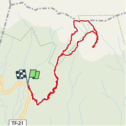
Trail Walking of 6.9 km to be discovered at Canary Islands, Santa Cruz de Tenerife, Vilaflor. This trail is proposed by pkermaidic.

Description

Rando facile à faire le matin.
Attention, quand nous sommes passés (oct 2016), un panneau interdisait l'accès du sentier les mercredi et vendredi; ce panneau se trouvait tout de même au-dessus du point 2

Elevation profile

Photos

Points of interest

Point of interest Vilaflor - Point 3 - Photo
pkermaidic
VILAFLOR 
Point of interest Vilaflor - Point 4 - Photo
pkermaidic
VILAFLOR 
Point of interest Vilaflor - Point 5 - Photo
pkermaidic
VILAFLOR 

Positioning

Country:
Spain
Region :
Canary Islands
Department/Province :
Santa Cruz de Tenerife
Municipality :
Vilaflor
Location:
Unknown
Start:(UTM)
337356 ; 3119228 (28R) N.


Close
My subscriptions