


Fleurines_Le Chêne à l'Image_Trace GPS simplifiée_9 km

Pousscailleux
User
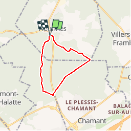

Length
8.6 km

Max alt
153 m

Uphill gradient
101 m
Km-Effort
10 km

Min alt
92 m

Downhill gradient
102 m
Boucle
Yes
Creation date :
2016-10-24 00:00:00.0
Updated on :
2016-10-24 00:00:00.0
2h17
Difficulty : Easy

FREE GPS app for hiking
 SityTrail
IGN / Geographical institutes
SityTrail Plus
The world is yours!
About
Trail Walking of 8.6 km to be discovered at Hauts-de-France, Oise, Fleurines. This trail is proposed by Pousscailleux.
Positioning
Country:
France
Region :
Hauts-de-France
Department/Province :
Oise
Municipality :
Fleurines
Location:
Unknown
Start:(Dec)
Start:(UTM)
469811 ; 5456038 (31U) N.
Comments