


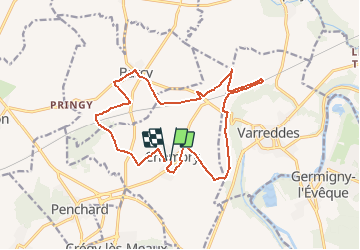
Chambry 16.4 km

GOELERANDO2
User

Length
16.4 km

Max alt
149 m

Uphill gradient
159 m
Km-Effort
18.5 km

Min alt
83 m

Downhill gradient
161 m
Boucle
Yes
Creation date :
2016-10-24 00:00:00.0
Updated on :
2016-10-24 00:00:00.0
4h02
Difficulty : Medium

FREE GPS app for hiking
 SityTrail
IGN / Geographical institutes
SityTrail Plus
The world is yours!
About
Trail Walking of 16.4 km to be discovered at Ile-de-France, Seine-et-Marne, Chambry. This trail is proposed by GOELERANDO2.
Description
Parking et départ de la Mairie de Chambly.
IGN 2513 OT
Lat. 48°59'54" N
Long. 2°53'37" E
A/R 38 km
Positioning
Country:
France
Region :
Ile-de-France
Department/Province :
Seine-et-Marne
Municipality :
Chambry
Location:
Unknown
Start:(Dec)
Start:(UTM)
492165 ; 5427209 (31U) N.
Comments