


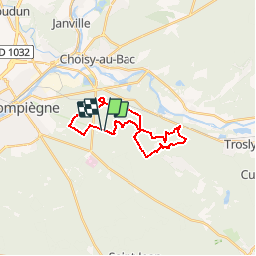
LES BEAUX MONTS 19.4 KM

GOELERANDO2
User

Length
19.4 km

Max alt
149 m

Uphill gradient
446 m
Km-Effort
25 km

Min alt
39 m

Downhill gradient
446 m
Boucle
Yes
Creation date :
2016-10-24 00:00:00.0
Updated on :
2016-10-24 00:00:00.0
4h29
Difficulty : Difficult

FREE GPS app for hiking
 SityTrail
IGN / Geographical institutes
SityTrail Plus
The world is yours!
About
Trail Walking of 19.4 km to be discovered at Hauts-de-France, Oise, Compiègne. This trail is proposed by GOELERANDO2.
Description
Les Beaux Monts à Compiègne 60
Départ du parking du Tréan
Carte IGN 2511 OT
Long. 2°52'98" E
Lat. 49°24'43" N
A/R 112 km
Positioning
Country:
France
Region :
Hauts-de-France
Department/Province :
Oise
Municipality :
Compiègne
Location:
Unknown
Start:(Dec)
Start:(UTM)
491485 ; 5472756 (31U) N.
Comments