


Crêt de l'Aigle

COMAN
User
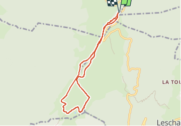

Length
7.8 km

Max alt
1694 m

Uphill gradient
224 m
Km-Effort
10.7 km

Min alt
1551 m

Downhill gradient
224 m
Boucle
Yes
Creation date :
2016-10-29 00:00:00.0
Updated on :
2016-10-29 00:00:00.0
2h34
Difficulty : Easy

FREE GPS app for hiking
 SityTrail
IGN / Geographical institutes
SityTrail Plus
The world is yours!
About
Trail Walking of 7.8 km to be discovered at Auvergne-Rhône-Alpes, Upper Savoy, Viuz-la-Chiésaz. This trail is proposed by COMAN.
Description
Depuis le Parking des Rochers Blanc (Restaurant) sous le Crêt de Chatillon - au Crêt de L'Aigle
Magnifique panorama à 360)
Positioning
Country:
France
Region :
Auvergne-Rhône-Alpes
Department/Province :
Upper Savoy
Municipality :
Viuz-la-Chiésaz
Location:
Unknown
Start:(Dec)
Start:(UTM)
275224 ; 5075808 (32T) N.
Comments