


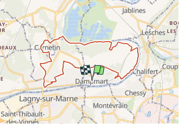
DAMPMART 19.4 km

GOELERANDO2
User

Length
19.4 km

Max alt
124 m

Uphill gradient
320 m
Km-Effort
24 km

Min alt
38 m

Downhill gradient
320 m
Boucle
Yes
Creation date :
2016-10-31 00:00:00.0
Updated on :
2016-10-31 00:00:00.0
5h00
Difficulty : Difficult

FREE GPS app for hiking
 SityTrail
IGN / Geographical institutes
SityTrail Plus
The world is yours!
About
Trail Walking of 19.4 km to be discovered at Ile-de-France, Seine-et-Marne, Dampmart. This trail is proposed by GOELERANDO2.
Description
Départ du parking près de l'Eglise.
Carte IGN 2414 ET
lONG. 2°44'20" E
Lat. 48°53'17" N
A/R Dammartin 46 km
Positioning
Country:
France
Region :
Ile-de-France
Department/Province :
Seine-et-Marne
Municipality :
Dampmart
Location:
Unknown
Start:(Dec)
Start:(UTM)
480651 ; 5414728 (31U) N.
Comments