


Nord - Pas-de-Calais - Ligne 000 Pont-de-la-Deule - Pont-à-Marcq

mich54
User

Length
27 km

Max alt
73 m

Uphill gradient
153 m
Km-Effort
29 km

Min alt
17 m

Downhill gradient
163 m
Boucle
No
Creation date :
2016-11-04 00:00:00.0
Updated on :
2016-11-04 00:00:00.0
5m
Difficulty : Unknown

FREE GPS app for hiking
 SityTrail
IGN / Geographical institutes
SityTrail Plus
The world is yours!
About
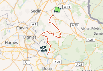
Trail Other activity of 27 km to be discovered at Hauts-de-France, Nord, Pont-à-Marcq. This trail is proposed by mich54.
Description
La Compagnie du chemin de fer de Pont-de-la-Deûle à Pont-à-Marcq(PDPM) est fondée le 3 novembre 1894 pour construire et exploiter un chemin de fer entre ces deux villes du département du Nord.
Positioning
Country:
France
Region :
Hauts-de-France
Department/Province :
Nord
Municipality :
Pont-à-Marcq
Location:
Unknown
Start:(Dec)
Start:(UTM)
507826 ; 5597487 (31U) N.
Comments
La fin du parcours est fausse et n'a jamais été (même en 2016) possible à cet endroit. Dommage de mettre dans la base de données des randos non faites sur le terrain