


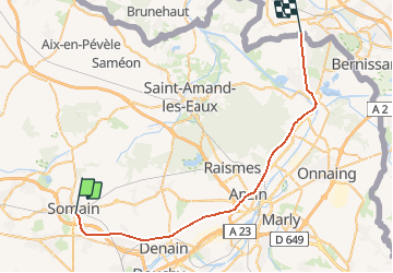
Nord - Pas-de-Calais - Ligne 092 - Somain - Péruwelz

mich54
User


5m
Difficulty : Unknown

FREE GPS app for hiking
 SityTrail
IGN / Geographical institutes
SityTrail Plus
The world is yours!
About
Trail Other activity of 35 km to be discovered at Hauts-de-France, Nord, Somain. This trail is proposed by mich54.
Description
Le chemin de fer de Somain (France) à Péruwelz (Belgique), plus souvent nommé ligne Somain – Péruwelz, situé dans le département du Nord, a été l'un des premiers chemins de fer de France. Il a été concédé le 24 octobre 1835 et ouvert entre 1838 et 1874. La dernière section ouverte au départ de Vieux-Condé traverse la frontière belge pour desservir Péruwelz en Belgique. L'exploitation se faisait sous le nom du Chemin de fer d'Anzin. (Source Wikipédia)
Positioning
Comments