


Mt Saint Martin départ Sallagrifon

rene06530
User
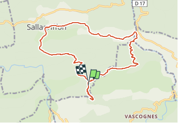

Length
11.6 km

Max alt
1170 m

Uphill gradient
663 m
Km-Effort
20 km

Min alt
557 m

Downhill gradient
677 m
Boucle
Yes
Creation date :
2016-11-02 00:00:00.0
Updated on :
2016-11-02 00:00:00.0
4h16
Difficulty : Difficult

FREE GPS app for hiking
 SityTrail
IGN / Geographical institutes
SityTrail Plus
The world is yours!
About
Trail Walking of 11.6 km to be discovered at Provence-Alpes-Côte d'Azur, Maritime Alps, Sallagriffon. This trail is proposed by rene06530.
Positioning
Country:
France
Region :
Provence-Alpes-Côte d'Azur
Department/Province :
Maritime Alps
Municipality :
Sallagriffon
Location:
Unknown
Start:(Dec)
Start:(UTM)
332921 ; 4859387 (32T) N.
Comments