


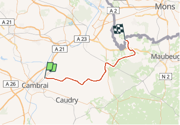
Nord - Pas-de-Calais - Ligne 251 - Escaudoeuvres - Cussignies

mich54
User

Length
53 km

Max alt
151 m

Uphill gradient
449 m
Km-Effort
59 km

Min alt
46 m

Downhill gradient
429 m
Boucle
No
Creation date :
2016-11-03 00:00:00.0
Updated on :
2016-11-03 00:00:00.0
5m
Difficulty : Unknown

FREE GPS app for hiking
 SityTrail
IGN / Geographical institutes
SityTrail Plus
The world is yours!
About
Trail Other activity of 53 km to be discovered at Hauts-de-France, Nord, Escaudœuvres. This trail is proposed by mich54.
Description
La ligne d'Escaudœuvres à Gussignies était une ligne ferroviaire française à écartement standard du département du Nord, qui permettait de relier la gare de Cambrai à Gussignies.(Source Wikipédia)
Positioning
Country:
France
Region :
Hauts-de-France
Department/Province :
Nord
Municipality :
Escaudœuvres
Location:
Unknown
Start:(Dec)
Start:(UTM)
520712 ; 5561010 (31U) N.
Comments