


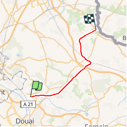
Nord - Pas-de-Calais - Ligne 264 - Pont-de-la-Deules - Bachy-Mouchin

mich54
User


5m
Difficulty : Unknown

FREE GPS app for hiking
 SityTrail
IGN / Geographical institutes
SityTrail Plus
The world is yours!
About
Trail Other activity of 24 km to be discovered at Hauts-de-France, Nord, Roost-Warendin. This trail is proposed by mich54.
Description
La ligne de Pont-de-la-Deûle à Bachy - Mouchin était une ligne ferroviaire non électrifiée à voie unique reliant la gare de Pont-de-la-Deûle (et indirectement celle de Douai) à la frontière franco-belge à Bachy et Mouchin via la gare d'Orchies. La ligne continuait ensuite en Belgique vers Tournai sous le nom de ligne 88A.(Source Wikipédia)
Positioning
Comments