Trail Other activity Pont-à-Marcq - Nord - Pas-de-Calais - Ligne 265 - Templeuve - Don-Sainghin 2 - Photo

Nord - Pas-de-Calais - Ligne 265 - Templeuve - Don-Sainghin 2

 mich54
mich54

User

© OpenStreetMap contributors
Length
Length
6.7 km
Max alt
Max alt
57 m
Uphill gradient
Uphill gradient
42 m
Km-Effort
Km-Effort  
7.2 km
Min alt
Min alt
32 m
Downhill gradient
Downhill gradient
35 m
Boucle
Boucle
No
Creation date :
2016-11-04 00:00:00.0
Updated on :
2016-11-04 00:00:00.0

(0 Reviews)

Other activity
Other activity
5m
Difficulty : Unknown

Scan this QR Code to open this trail in the SityTrail application

FREE GPS app for hiking

Logo SityTrail SityTrail

IGN / Geographical institutes

Download SityTrail from the App Store Download SityTrail from Google Play

Logo SityTrail SityTrail Plus

The world is yours!

Download SityTrail from the App Store Download SityTrail from Google Play Download SityTrail on Huawei AppGallery

About

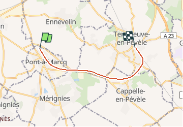
Trail Other activity of 6.7 km to be discovered at Hauts-de-France, Nord, Pont-à-Marcq. This trail is proposed by mich54.

Description

Section de Pont-à-Marcq à Templeuve.
La ligne de Templeuve à Don-Sainghin était une ligne ferroviaire française non électrifiée à voie unique reliant la gare de Templeuve à celle de Don-Sainghin, via Seclin.(Source Wikipédia)

Elevation profile

Positioning

Country:
France
Region :
Hauts-de-France
Department/Province :
Nord
Municipality :
Pont-à-Marcq
Location:
Unknown
Start:(UTM)
507915 ; 5597322 (31U) N.


Close
My subscriptions