Trail Other activity Wavrin - Nord - Pas-de-Calais - Ligne 293 - Wavrin - Armentières - Photo

Nord - Pas-de-Calais - Ligne 293 - Wavrin - Armentières

 mich54
mich54

User

© OpenStreetMap contributors
Length
Length
13.3 km
Max alt
Max alt
40 m
Uphill gradient
Uphill gradient
54 m
Km-Effort
Km-Effort  
14 km
Min alt
Min alt
16 m
Downhill gradient
Downhill gradient
64 m
Boucle
Boucle
No
Creation date :
2016-11-04 00:00:00.0
Updated on :
2016-11-04 00:00:00.0

(0 Reviews)

Other activity
Other activity
5m
Difficulty : Unknown

Scan this QR Code to open this trail in the SityTrail application

FREE GPS app for hiking

Logo SityTrail SityTrail

IGN / Geographical institutes

Download SityTrail from the App Store Download SityTrail from Google Play

Logo SityTrail SityTrail Plus

The world is yours!

Download SityTrail from the App Store Download SityTrail from Google Play Download SityTrail on Huawei AppGallery

About

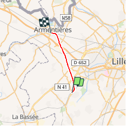
Trail Other activity of 13.3 km to be discovered at Hauts-de-France, Nord, Wavrin. This trail is proposed by mich54.

Description

La ligne de Wavrin à Armentières est une ligne ferroviaire française non électrifiée à écartement standard et à voie unique reliant la gare de Wavrin à celle d'Armentières. Elle est déposée sur une partie de son parcours, et uniquement praticable d'Armentières jusqu'au nord de la LGV Nord.(Source Wikipédia)

Elevation profile

Positioning

Country:
France
Region :
Hauts-de-France
Department/Province :
Nord
Municipality :
Wavrin
Location:
Unknown
Start:(UTM)
495481 ; 5602504 (31U) N.


Close
My subscriptions