Trail Other activity Grenay - Nord - Pas-de-Calais - Ligne 309 - Bully-Granay - Brias - Photo

Nord - Pas-de-Calais - Ligne 309 - Bully-Granay - Brias

 mich54
mich54

User

© OpenStreetMap contributors
Length
Length
30 km
Max alt
Max alt
166 m
Uphill gradient
Uphill gradient
296 m
Km-Effort
Km-Effort  
34 km
Min alt
Min alt
42 m
Downhill gradient
Downhill gradient
197 m
Boucle
Boucle
No
Creation date :
2016-11-21 00:00:00.0
Updated on :
2016-11-21 00:00:00.0

(0 Reviews)

Other activity
Other activity
5m
Difficulty : Unknown

Scan this QR Code to open this trail in the SityTrail application

FREE GPS app for hiking

Logo SityTrail SityTrail

IGN / Geographical institutes

Download SityTrail from the App Store Download SityTrail from Google Play

Logo SityTrail SityTrail World

The world is yours!

Download SityTrail from the App Store Download SityTrail from Google Play Download SityTrail on Huawei AppGallery

About

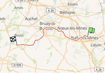
Trail Other activity of 30 km to be discovered at Hauts-de-France, Pas-de-Calais, Grenay. This trail is proposed by mich54.

Description

La ligne de Bully-Grenay à Brias était une ligne ferroviaire française de la région Nord-Pas-de-Calais non électrifiée à voie unique reliant la gare de Bully - Grenay à celle de Brias. La ligne prend naissance à Bully-les-Mines, près de la gare, à partir de la ligne d'Arras à Dunkerque-Locale, et se termine en rejoignant la ligne de Fives à Abbeville, près de la gare de Brias. Au XXIe siècle, la ligne n'est plus utilisée. La voie est conservée mais abandonnée de Bully-les-Mines à Bruay-la-Buissière et déposée au-delà.(Source Wikipédia)

Elevation profile

Positioning

Country:
France
Region :
Hauts-de-France
Department/Province :
Pas-de-Calais
Municipality :
Grenay
Location:
Unknown
Start:(UTM)
481075 ; 5588536 (31U) N.

Trails nearby

Trail Walking Liévin - 50 km Lievin en nocturne - Photo
Walking
tracegps

Walking

Very difficult
(1)
Liévin, Hauts-de-France, Pas-de-Calais, France
52 km | 61 km-effort
9h 0min
Yes
Trail Walking Angres - randonnée pinchonvalles - Photo
Walking
Chene62

Walking

Very difficult
Angres, Hauts-de-France, Pas-de-Calais, France
27 km | 0 m-effort
3h 24min
No
Trail Other activity Liévin - boucle Liévin - Photo
Other activity
crijack

Other activity

Very easy
Liévin, Hauts-de-France, Pas-de-Calais, France
11 km | 12.3 km-effort
2h 2min
Yes
Trail Other activity Liévin - boucle Liévin - Photo
Other activity
crijack

Other activity

Very easy
Liévin, Hauts-de-France, Pas-de-Calais, France
11 km | 12.3 km-effort
2h 2min
Yes
Trail Running Aix-Noulette - aix noulette sity guide 25,3 km D530+ - Photo
Running
jamboxland

Running

Medium
Aix-Noulette, Hauts-de-France, Pas-de-Calais, France
23 km | 30 km-effort
2h 45min
Yes
Trail Walking Vermelles - Autour de Vermellles - Photo
Walking
tracegps

Walking

Difficult
(1)
Vermelles, Hauts-de-France, Pas-de-Calais, France
15.8 km | 16.6 km-effort
4h 0min
Yes
Trail Walking Noyelles-lès-Vermelles - La voie ferrée - Noyelles-lès-Vermelles - Photo
Walking
tracegps

Walking

Difficult
Noyelles-lès-Vermelles, Hauts-de-France, Pas-de-Calais, France
13.7 km | 14.6 km-effort
3h 25min
Yes
Trail Walking Bouvigny-Boyeffles - bouvigny - Photo
Walking
totof62

Walking

Difficult
Bouvigny-Boyeffles, Hauts-de-France, Pas-de-Calais, France
14.2 km | 17.3 km-effort
3h 54min
Yes
Trail Mountain bike Angres - La randonnée VTT du Père Noël - Angres - Photo
Mountain bike
tracegps

Mountain bike

Difficult
(1)
Angres, Hauts-de-France, Pas-de-Calais, France
35 km | 42 km-effort
3h 0min
Yes


Close
My subscriptions