


La tête du Danay

bourel.jacques
User

Length
11.7 km

Max alt
1715 m

Uphill gradient
571 m
Km-Effort
19.3 km

Min alt
1214 m

Downhill gradient
570 m
Boucle
Yes
Creation date :
2016-11-16 00:00:00.0
Updated on :
2016-11-16 00:00:00.0
4h08
Difficulty : Medium

FREE GPS app for hiking
 SityTrail
IGN / Geographical institutes
SityTrail Plus
The world is yours!
About
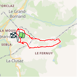
Trail Walking of 11.7 km to be discovered at Auvergne-Rhône-Alpes, Upper Savoy, Saint-Jean-de-Sixt. This trail is proposed by bourel.jacques.
Positioning
Country:
France
Region :
Auvergne-Rhône-Alpes
Department/Province :
Upper Savoy
Municipality :
Saint-Jean-de-Sixt
Location:
Unknown
Start:(Dec)
Start:(UTM)
300548 ; 5088306 (32T) N.
Comments