


CHAUMONT EN VEXIN - CHARS

NUITEVEN
User
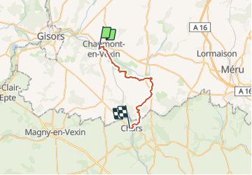

Length
24 km

Max alt
151 m

Uphill gradient
378 m
Km-Effort
29 km

Min alt
63 m

Downhill gradient
396 m
Boucle
No
Creation date :
2016-11-09 00:00:00.0
Updated on :
2016-11-09 00:00:00.0
6h15
Difficulty : Easy

FREE GPS app for hiking
 SityTrail
IGN / Geographical institutes
SityTrail Plus
The world is yours!
About
Trail Walking of 24 km to be discovered at Hauts-de-France, Oise, Chaumont-en-Vexin. This trail is proposed by NUITEVEN.
Positioning
Country:
France
Region :
Hauts-de-France
Department/Province :
Oise
Municipality :
Chaumont-en-Vexin
Location:
Unknown
Start:(Dec)
Start:(UTM)
417995 ; 5457129 (31U) N.
Comments