


Illies 8.1 km

Blourouce
User
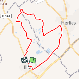

Length
8.1 km

Max alt
41 m

Uphill gradient
49 m
Km-Effort
8.7 km

Min alt
22 m

Downhill gradient
51 m
Boucle
Yes
Creation date :
2019-01-12 16:54:23.069
Updated on :
2019-01-12 16:54:23.09
1h57
Difficulty : Unknown

FREE GPS app for hiking
 SityTrail
IGN / Geographical institutes
SityTrail Plus
The world is yours!
About
Trail Walking of 8.1 km to be discovered at Hauts-de-France, Nord, Illies. This trail is proposed by Blourouce.
Positioning
Country:
France
Region :
Hauts-de-France
Department/Province :
Nord
Municipality :
Illies
Location:
Unknown
Start:(Dec)
Start:(UTM)
488062 ; 5601098 (31U) N.
Comments