


Départ Aumont en H

domifon
User
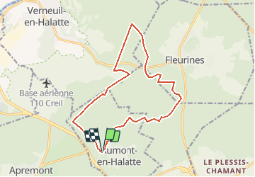

Length
14.7 km

Max alt
148 m

Uphill gradient
165 m
Km-Effort
16.9 km

Min alt
82 m

Downhill gradient
167 m
Boucle
Yes
Creation date :
2014-12-10 00:00:00.0
Updated on :
2014-12-10 00:00:00.0
--
Difficulty : Unknown

FREE GPS app for hiking
 SityTrail
IGN / Geographical institutes
SityTrail Plus
The world is yours!
About
Trail Nordic walking of 14.7 km to be discovered at Hauts-de-France, Oise, Aumont-en-Halatte. This trail is proposed by domifon.
Description
Depart Pkg Aumont en Halatte puis 14.6 kms
Positioning
Country:
France
Region :
Hauts-de-France
Department/Province :
Oise
Municipality :
Aumont-en-Halatte
Location:
Unknown
Start:(Dec)
Start:(UTM)
466968 ; 5453213 (31U) N.
Comments