


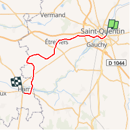
Picardie - Ligne 00A - St-Quentin - Ham

mich54
User


5m
Difficulty : Unknown

FREE GPS app for hiking
 SityTrail
IGN / Geographical institutes
SityTrail Plus
The world is yours!
About
Trail Other activity of 28 km to be discovered at Hauts-de-France, Aisne, Saint-Quentin. This trail is proposed by mich54.
Description
La ligne de Saint-Quentin à Ham était une ligne ferroviaire secondaire longue de 28 kilomètres, à voie unique et écartement standard, permettant de relier la grande artère de Paris à Bruxelles qui passe en gare de Saint-Quentin, dans l'Aisne, avec la ligne d'Amiens à Laon qui passe en gare de Ham dans la Somme.
Mise en service dans son intégralité en 1912, le dernier tronçon est fermé dans les années 1990. Elle est ensuite déclassée et déposée.
La Régie des transports de l'Aisne (RTA), met fin au trafic voyageurs sur l'ensemble de la ligne le 14 février 19554.(Source Wikipédia)
Positioning
Comments