


Reims 3.2 km

GOELERANDO2
User

Length
3.6 km

Max alt
99 m

Uphill gradient
24 m
Km-Effort
3.9 km

Min alt
80 m

Downhill gradient
23 m
Boucle
Yes
Creation date :
2016-11-27 00:00:00.0
Updated on :
2016-11-27 00:00:00.0
46m
Difficulty : Very easy

FREE GPS app for hiking
 SityTrail
IGN / Geographical institutes
SityTrail Plus
The world is yours!
About
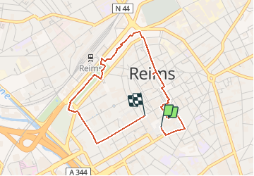
Trail Walking of 3.6 km to be discovered at Grand Est, Marne, Reims. This trail is proposed by GOELERANDO2.
Description
Circuit au départ de la Cathédrale, vers une coulée verte. Arrivée au niveau du palais de justice.
Positioning
Country:
France
Region :
Grand Est
Department/Province :
Marne
Municipality :
Reims
Location:
Unknown
Start:(Dec)
Start:(UTM)
575172 ; 5456146 (31U) N.
Comments