


haute jarrie - saut du moine

maupassant38
User
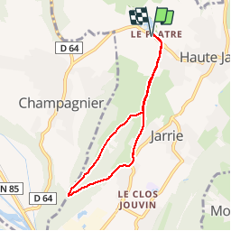

Length
6.4 km

Max alt
443 m

Uphill gradient
166 m
Km-Effort
8.6 km

Min alt
299 m

Downhill gradient
166 m
Boucle
Yes
Creation date :
2019-02-22 22:31:07.165
Updated on :
2019-02-22 22:31:07.176
1h47
Difficulty : Easy

FREE GPS app for hiking
 SityTrail
IGN / Geographical institutes
SityTrail Plus
The world is yours!
About
Trail Walking of 6.4 km to be discovered at Auvergne-Rhône-Alpes, Isère, Jarrie. This trail is proposed by maupassant38.
Positioning
Country:
France
Region :
Auvergne-Rhône-Alpes
Department/Province :
Isère
Municipality :
Jarrie
Location:
Unknown
Start:(Dec)
Start:(UTM)
715952 ; 4999810 (31T) N.
Comments