


Le Bernard

Gascon
User

Length
13 km

Max alt
27 m

Uphill gradient
78 m
Km-Effort
14 km

Min alt
5 m

Downhill gradient
77 m
Boucle
Yes
Creation date :
2016-11-28 00:00:00.0
Updated on :
2016-11-28 00:00:00.0
3h06
Difficulty : Unknown

FREE GPS app for hiking
 SityTrail
IGN / Geographical institutes
SityTrail Plus
The world is yours!
About
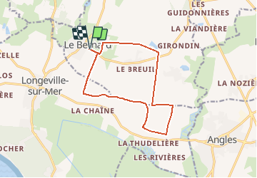
Trail Walking of 13 km to be discovered at Pays de la Loire, Vendée, Le Bernard. This trail is proposed by Gascon.
Positioning
Country:
France
Region :
Pays de la Loire
Department/Province :
Vendée
Municipality :
Le Bernard
Location:
Unknown
Start:(Dec)
Start:(UTM)
617811 ; 5143765 (30T) N.
Comments