


MONT PAGNOTTE 13.8 km

GOELERANDO2
User
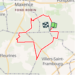

Length
13.8 km

Max alt
231 m

Uphill gradient
276 m
Km-Effort
17.6 km

Min alt
62 m

Downhill gradient
287 m
Boucle
Yes
Creation date :
2016-11-30 00:00:00.0
Updated on :
2016-11-30 00:00:00.0
3h45
Difficulty : Difficult

FREE GPS app for hiking
 SityTrail
IGN / Geographical institutes
SityTrail Plus
The world is yours!
About
Trail Walking of 13.8 km to be discovered at Hauts-de-France, Oise, Pontpoint. This trail is proposed by GOELERANDO2.
Description
Départ du parking du Poteau du Mont-Pagnotte près de Villers St.Frambourg.
Positioning
Country:
France
Region :
Hauts-de-France
Department/Province :
Oise
Municipality :
Pontpoint
Location:
Unknown
Start:(Dec)
Start:(UTM)
473474 ; 5458446 (31U) N.
Comments