


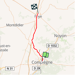
Picardie - Ligne 248 - Compiègne - Roye-Faubourg-Saint-Gilles

mich54
User


5m
Difficulty : Unknown

FREE GPS app for hiking
 SityTrail
IGN / Geographical institutes
SityTrail Plus
The world is yours!
About
Trail Other activity of 37 km to be discovered at Hauts-de-France, Oise, Margny-lès-Compiègne. This trail is proposed by mich54.
Description
La ligne de Compiègne à Roye-Faubourg-Saint-Gilles est une ligne de chemin de fer du réseau ferré français. Elle reliait Compiègne à Roye (Somme), à travers les départements de l'Oise et de la Somme, en région Picardie. La ligne est aujourd'hui fermée à tout trafic et en partie déposée, mais la section de Compiègne à Roye-sur-Matz n'est pas encore déclassée.(Source Wikipédia)
Positioning
Comments