Trail Other activity Abbeville - Picardie - Ligne 289 - St-Pol-de-Ternoise - Abbeville (Section Auxi-le-Château Abbeville) - Photo

Picardie - Ligne 289 - St-Pol-de-Ternoise - Abbeville (Section Auxi-le-Château Abbeville)

 mich54
mich54

User

© OpenStreetMap contributors
Length
Length
32 km
Max alt
Max alt
134 m
Uphill gradient
Uphill gradient
298 m
Km-Effort
Km-Effort  
36 km
Min alt
Min alt
2 m
Downhill gradient
Downhill gradient
266 m
Boucle
Boucle
No
Creation date :
2016-12-03 00:00:00.0
Updated on :
2016-12-03 00:00:00.0

(0 Reviews)

Other activity
Other activity
5m
Difficulty : Unknown

Scan this QR Code to open this trail in the SityTrail application

FREE GPS app for hiking

Logo SityTrail SityTrail

IGN / Geographical institutes

Download SityTrail from the App Store Download SityTrail from Google Play

Logo SityTrail SityTrail Plus

The world is yours!

Download SityTrail from the App Store Download SityTrail from Google Play Download SityTrail on Huawei AppGallery

About

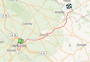
Trail Other activity of 32 km to be discovered at Hauts-de-France, Somme, Abbeville. This trail is proposed by mich54.

Description

La ligne de Fives à Abbeville est une ligne ferroviaire française à écartement standard de la région Hauts-de-France. Elle relie la gare de Lille-Flandres à celle de Saint-Pol-sur-Ternoise. Elle continuait autrefois jusqu'à la gare d'Abbeville.

Elle constitue la ligne no 289 0001 du réseau ferré national.
Déclassement:
Section de Auxi-le-Château à Abbeville (PK 102,300 à 134,130) : 17 octobre 1994.(Source Wikipédia)

Elevation profile

Positioning

Country:
France
Region :
Hauts-de-France
Department/Province :
Somme
Municipality :
Abbeville
Location:
Unknown
Start:(UTM)
415848 ; 5550747 (31U) N.


Close
My subscriptions