


pic de l'ours-variante

rene06530
User

Length
12 km

Max alt
489 m

Uphill gradient
503 m
Km-Effort
18.7 km

Min alt
14 m

Downhill gradient
504 m
Boucle
Yes
Creation date :
2016-12-03 00:00:00.0
Updated on :
2016-12-03 00:00:00.0
4h06
Difficulty : Medium

FREE GPS app for hiking
 SityTrail
IGN / Geographical institutes
SityTrail Plus
The world is yours!
About
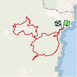
Trail Walking of 12 km to be discovered at Provence-Alpes-Côte d'Azur, Var, Saint-Raphaël. This trail is proposed by rene06530.
Description
Gare du Trayas-col de l'eveque-col des lentisques-pic de l'ours-grotte de l'uzel-col des lentisques-gare du trayas.
Positioning
Country:
France
Region :
Provence-Alpes-Côte d'Azur
Department/Province :
Var
Municipality :
Saint-Raphaël
Location:
Unknown
Start:(Dec)
Start:(UTM)
332065 ; 4815531 (32T) N.
Comments