


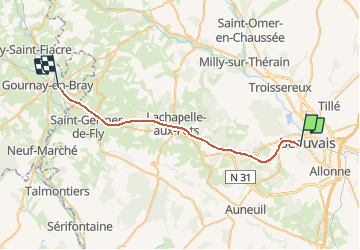
Picardie - Ligne 333 - Goincourt - Gournay - Ferrières

mich54
User


5m
Difficulty : Unknown

FREE GPS app for hiking
 SityTrail
IGN / Geographical institutes
SityTrail Plus
The world is yours!
About
Trail Other activity of 27 km to be discovered at Hauts-de-France, Oise, Beauvais. This trail is proposed by mich54.
Description
La ligne de Goincourt à Gournay - Ferrières est une ancienne ligne de chemin de fer du réseau ferré français. Elle reliait Goincourt (à proximité de Beauvais) à Gournay - Ferrières à travers les départements de l'Oise et de la Seine-Maritime et des régions Picardie et Haute-Normandie.
Elle constitue la ligne n°333 0001 du réseau ferré national.
Date de fermeture
La ligne a été fermée à tous trafics entre Saint-Paul et Gournay - Ferrières (PK 8,396 à 29,273) le 15 avril 2010 puis entre Rainvillers et Saint-Paul-de-l'Oise (PK 6,216 à 8,396) le 7 février 2013.(Source Wikipédia)
Positioning
Comments