


monts en bessin 12 kms pplar 2016

aubinjoel
User
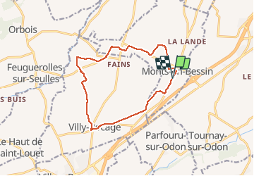

Length
12.3 km

Max alt
202 m

Uphill gradient
167 m
Km-Effort
14.6 km

Min alt
98 m

Downhill gradient
168 m
Boucle
Yes
Creation date :
2016-12-12 00:00:00.0
Updated on :
2016-12-12 00:00:00.0
--
Difficulty : Medium

FREE GPS app for hiking
 SityTrail
IGN / Geographical institutes
SityTrail Plus
The world is yours!
About
Trail Walking of 12.3 km to be discovered at Normandy, Calvados, Monts-en-Bessin. This trail is proposed by aubinjoel.
Positioning
Country:
France
Region :
Normandy
Department/Province :
Calvados
Municipality :
Monts-en-Bessin
Location:
Unknown
Start:(Dec)
Start:(UTM)
674814 ; 5442620 (30U) N.
Comments