


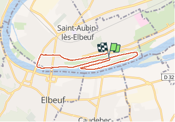
20161213 port St aubin

doudet
User

Length
7.6 km

Max alt
18 m

Uphill gradient
50 m
Km-Effort
8.3 km

Min alt
0 m

Downhill gradient
49 m
Boucle
Yes
Creation date :
2018-09-11 09:11:21.479
Updated on :
2018-09-11 09:11:21.479
2h00
Difficulty : Very easy

FREE GPS app for hiking
 SityTrail
IGN / Geographical institutes
SityTrail Plus
The world is yours!
About
Trail Walking of 7.6 km to be discovered at Normandy, Seine-Maritime, Saint-Aubin-lès-Elbeuf. This trail is proposed by doudet.
Positioning
Country:
France
Region :
Normandy
Department/Province :
Seine-Maritime
Municipality :
Saint-Aubin-lès-Elbeuf
Location:
Unknown
Start:(Dec)
Start:(UTM)
356820 ; 5462297 (31U) N.
Comments