


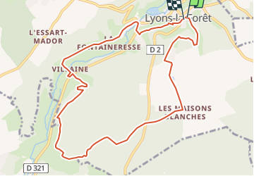
Lyons la Cuette le Val Aux Anes

serge.guerroult
User

Length
10.3 km

Max alt
181 m

Uphill gradient
220 m
Km-Effort
13.2 km

Min alt
72 m

Downhill gradient
218 m
Boucle
Yes
Creation date :
2016-12-16 00:00:00.0
Updated on :
2024-03-22 17:47:06.221
1h40
Difficulty : Medium

FREE GPS app for hiking
 SityTrail
IGN / Geographical institutes
SityTrail Plus
The world is yours!
About
Trail Nordic walking of 10.3 km to be discovered at Normandy, Eure, Lyons-la-Forêt. This trail is proposed by serge.guerroult.
Description
le chemin du roule vilaine la fontaineresse les moulins
Positioning
Country:
France
Region :
Normandy
Department/Province :
Eure
Municipality :
Lyons-la-Forêt
Location:
Unknown
Start:(Dec)
Start:(UTM)
389645 ; 5472938 (31U) N.
Comments