


MONT MACARON PAR BORDINAS

ccrelais
User
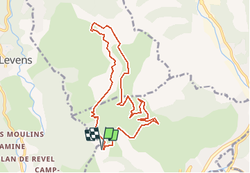

Length
9.8 km

Max alt
788 m

Uphill gradient
392 m
Km-Effort
15 km

Min alt
471 m

Downhill gradient
388 m
Boucle
Yes
Creation date :
2016-12-17 00:00:00.0
Updated on :
2016-12-17 00:00:00.0
--
Difficulty : Unknown

FREE GPS app for hiking
 SityTrail
IGN / Geographical institutes
SityTrail Plus
The world is yours!
About
Trail Mountain bike of 9.8 km to be discovered at Provence-Alpes-Côte d'Azur, Maritime Alps, Cantaron. This trail is proposed by ccrelais.
Positioning
Country:
France
Region :
Provence-Alpes-Côte d'Azur
Department/Province :
Maritime Alps
Municipality :
Cantaron
Location:
Unknown
Start:(Dec)
Start:(UTM)
363165 ; 4847901 (32T) N.
Comments