


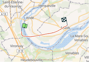
Haute - Normandie - Ligne 343 - Saint-Pierre-du-Vauvray - Les Andelys

mich54
User

Length
5.3 km

Max alt
37 m

Uphill gradient
46 m
Km-Effort
5.9 km

Min alt
6 m

Downhill gradient
43 m
Boucle
No
Creation date :
2016-12-20 00:00:00.0
Updated on :
2016-12-20 00:00:00.0
5m
Difficulty : Unknown

FREE GPS app for hiking
 SityTrail
IGN / Geographical institutes
SityTrail Plus
The world is yours!
About
Trail Other activity of 5.3 km to be discovered at Normandy, Eure, Saint-Pierre-du-Vauvray. This trail is proposed by mich54.
Description
La ligne de Saint-Pierre-du-Vauvray aux Andelys est une ancienne ligne de chemin de fer qui reliait Saint-Pierre-du-Vauvray aux Andelys.(Source Wikipédia)
Positioning
Country:
France
Region :
Normandy
Department/Province :
Eure
Municipality :
Saint-Pierre-du-Vauvray
Location:
Unknown
Start:(Dec)
Start:(UTM)
370876 ; 5453354 (31U) N.
Comments