


Forges A9

Blixsup
User

Length
21 km

Max alt
189 m

Uphill gradient
256 m
Km-Effort
24 km

Min alt
118 m

Downhill gradient
259 m
Boucle
Yes
Creation date :
2016-12-21 00:00:00.0
Updated on :
2016-12-21 00:00:00.0
5h14
Difficulty : Medium

FREE GPS app for hiking
 SityTrail
IGN / Geographical institutes
SityTrail Plus
The world is yours!
About
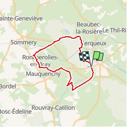
Trail Walking of 21 km to be discovered at Normandy, Seine-Maritime, Forges-les-Eaux. This trail is proposed by Blixsup.
Description
RONCHEROLLES-EN-BRAY
FORGES-LES-EAUX
Positioning
Country:
France
Region :
Normandy
Department/Province :
Seine-Maritime
Municipality :
Forges-les-Eaux
Location:
Forges-les-Eaux
Start:(Dec)
Start:(UTM)
394152 ; 5496245 (31U) N.
Comments